Voici la commandes que j’utilises pour forcer le scan des photos :
sudo -u www-data php7.3 /usr/share/nginx/nextcloud/occ maps:scan-photos
Le lien vers l’application :

Voici la commandes que j’utilises pour forcer le scan des photos :
sudo -u www-data php7.3 /usr/share/nginx/nextcloud/occ maps:scan-photos
Le lien vers l’application :
Step 0 : Install Joplin and activate the REST API ( https://joplin.cozic.net/api/ ) .
Step 1: Install staticmap with pip ( for more information see https://github.com/komoot/staticmap )
$ pip install staticmap
Collecting staticmap
  Downloading https://files.pythonhosted.org/packages/f9/9f/5a3843533eab037cba031486175c4db1b214614404a29516208ff228dead/staticmap-0.5.4.tar.gz
Collecting Pillow (from staticmap)
  Downloading https://files.pythonhosted.org/packages/c9/ed/27cc92e99b9ccaa0985a66133baeea7e8a3371d3c04cfa353aaa3b81aac1/Pillow-5.4.1-cp37-cp37m-macosx_10_6_intel.macosx_10_9_intel.macosx_10_9_x86_64.macosx_10_10_intel.macosx_10_10_x86_64.whl (3.7MB)
    100% |████████████████████████████████| 3.7MB 6.3MB/s
Requirement already satisfied: requests in /usr/local/lib/python3.7/site-packages (from staticmap) (2.21.0)
Requirement already satisfied: chardet<3.1.0,>=3.0.2 in /usr/local/lib/python3.7/site-packages (from requests->staticmap) (3.0.4)
Requirement already satisfied: idna<2.9,>=2.5 in /usr/local/lib/python3.7/site-packages (from requests->staticmap) (2.8)
Requirement already satisfied: urllib3<1.25,>=1.21.1 in /usr/local/lib/python3.7/site-packages (from requests->staticmap) (1.24.1)
Requirement already satisfied: certifi>=2017.4.17 in /usr/local/lib/python3.7/site-packages (from requests->staticmap) (2018.11.29)
Building wheels for collected packages: staticmap
  Building wheel for staticmap (setup.py) ... done
  Stored in directory: /Users/..../Library/Caches/pip/wheels/fe/a6/a5/2acceb72471d85bd0498973aabd611e6ff1cdd48796790f047
Successfully built staticmap
Installing collected packages: Pillow, staticmap
Successfully installed Pillow-5.4.1 staticmap-0.5.4
The source code :
#
# Version 1
# for Python 3
#
#   ARIAS Frederic
#   Sorry ... It's difficult for me the python :)
#

from time import gmtime, strftime
import time
import json
import requests
import os
import gmplot
from staticmap import StaticMap, CircleMarker

m = StaticMap(1600, 800, url_template='http://a.tile.osm.org/{z}/{x}/{y}.png')

marker = CircleMarker((10, 47), '#0036FF', 3)
m.add_marker(marker)

#Token
ip = "127.0.0.1"
port = "41184"

token = "Put your token here"
nb_request = 0
nb_plot = 0
headers = {'Content-type': 'application/json', 'Accept': 'text/plain'}
url_notes = (
    "http://"+ip+":"+port+"/notes?"
    "token="+token
)
try:
    resp = requests.get(url_notes, headers=headers)
    nb_request += 1
    resp.raise_for_status()
    resp_dict = resp.json()
    #print(resp_dict)
    for my_note in resp_dict:
        #print(my_note.get('id'))
        url_notes2 = (
    "http://"+ip+":"+port+"/notes/"+my_note.get('id')+"?fields=longitude,latitude&"
    "token="+token
)
        try:
           resp2 = requests.get(url_notes2, headers=headers)
           nb_request += 1
           resp2.raise_for_status()
           resp_dict2 = resp2.json()
           #print(resp_dict2)
           long = resp_dict2.get('longitude')
           lat = resp_dict2.get('latitude')
           if (long != '0.00000000'):
              nb_plot += 1
              marker = CircleMarker((float(long), float(lat)), '#0036FF', 12)
              m.add_marker(marker)
        except requests.exceptions.HTTPError as e:
             print("Bad HTTP status code:", e)
        except requests.exceptions.RequestException as e:
             print("Network error:", e)
except requests.exceptions.HTTPError as e:
    print("Bad HTTP status code:", e)
except requests.exceptions.RequestException as e:
    print("Network error:", e)

image = m.render(zoom=1)
image.save('mymap_zoom1.png')
image = m.render(zoom=2)
image.save('mymap_zoom2.png')
image = m.render(zoom=3)
image.save('mymap_zoom3.png')
image = m.render(zoom=4)
image.save('mymap_zoom4.png')
image = m.render(zoom=5)
image.save('mymap_zoom5.png')
image = m.render(zoom=6)
image.save('mymap_zoom6.png')

print ("Number total of request",nb_request)
print ("Number total of pin",nb_plot)
On same folder, you see mymap_zoom*.png .
To change the size of map, it’s here : ( by default 1600 x 800 )
m = StaticMap(1600, 800, url_template='http://a.tile.osm.org/{z}/{x}/{y}.png')Time to build the pictures :
$ time python3 JoplinToStaticMap.py
Number total of request 1927
Number total of pin 643

real	0m18.137s
user	0m7.936s
sys	0m0.876s
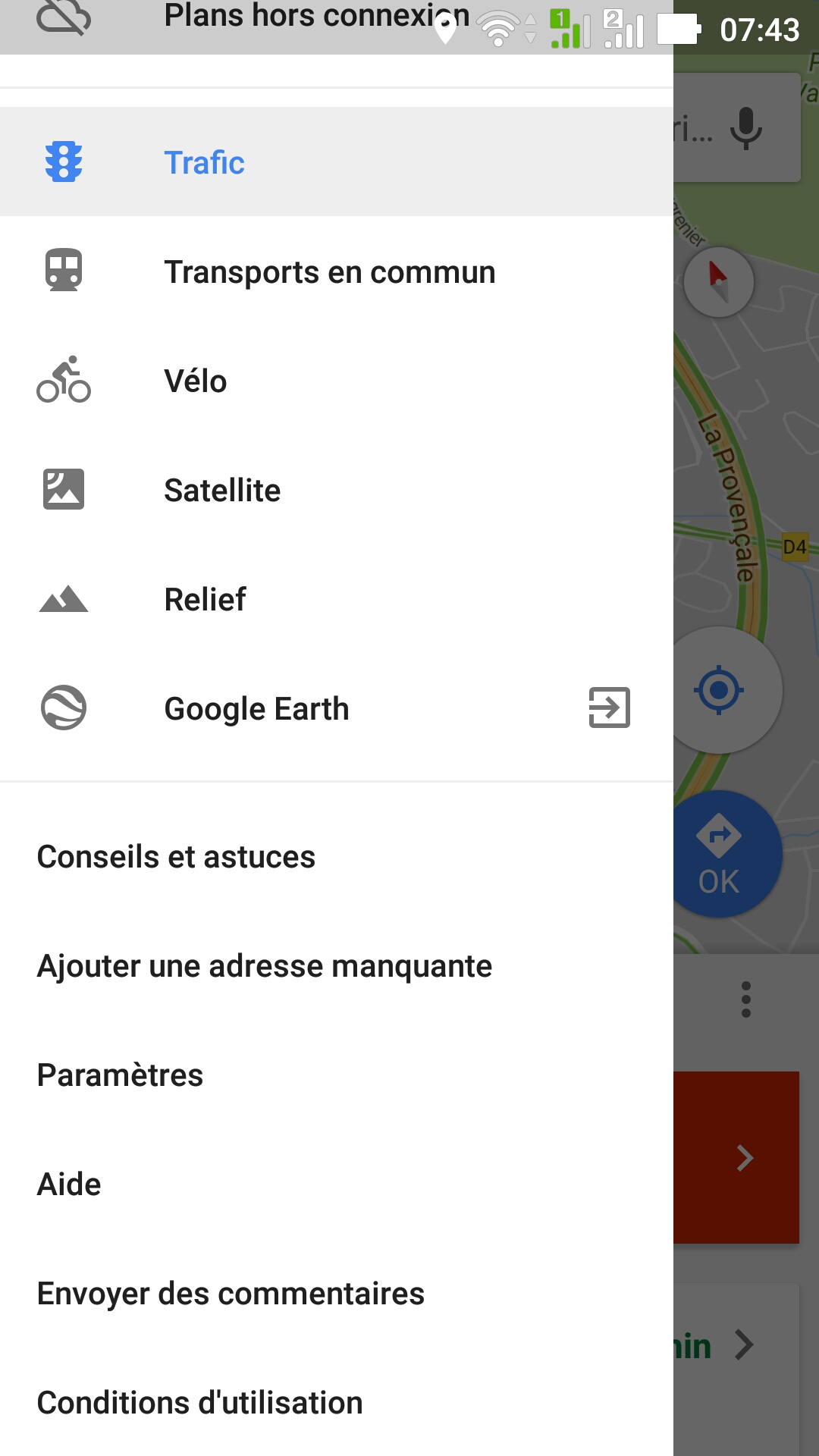
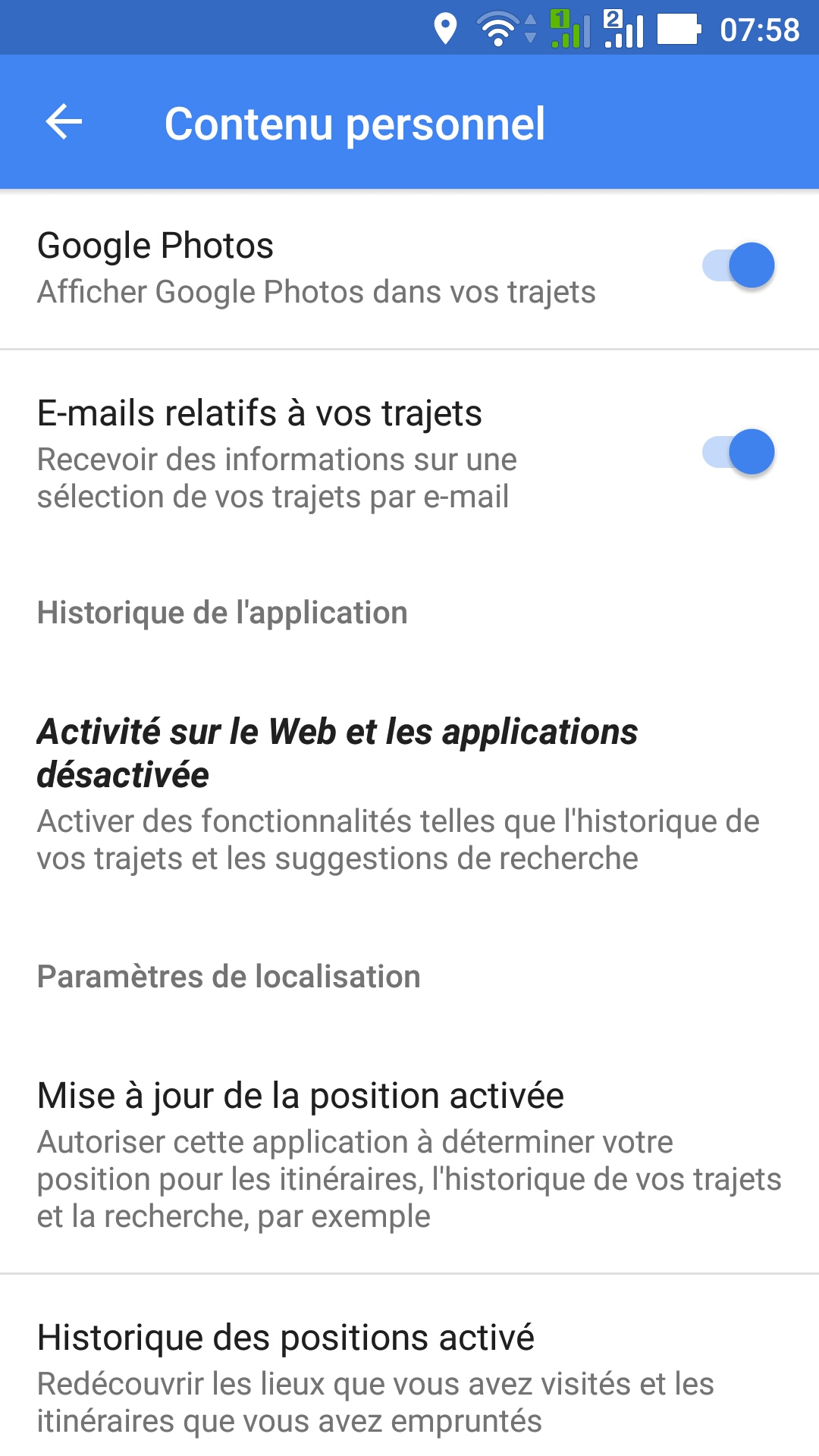
Google fait du tracking via Maps, le supprimer permet de gagner en autonomie sur le téléphone mais aussi en vie privé.
Il suffit de lancer Map, puis Paramètres, puis Contenu Personnel, puis Historique des positions et désactivé les appareils.
Pour mieux se rendre compte de ce que fait google il suffit d’aller sur : https://www.google.com/maps/timeline .
Le plugin : http://wordpress.org/plugins/wp-gpx-maps/screenshots/ .
Ensuite on exporte le fichier GPX :
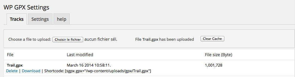 Et on copie le Shortcode dans l’article.
Exemple :